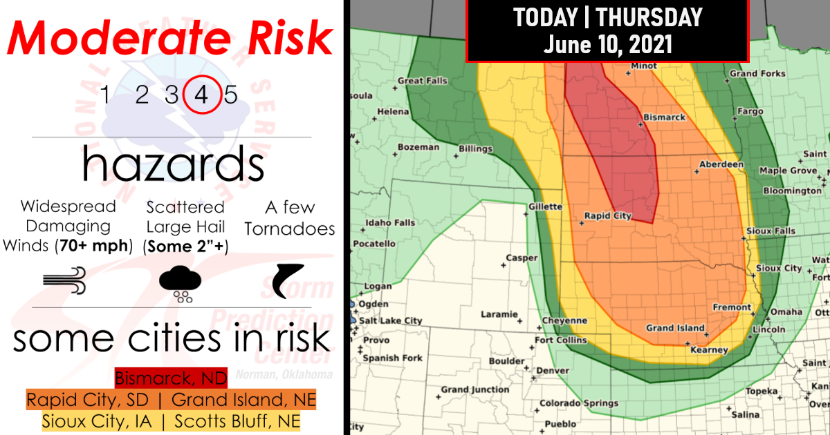
Significant severe weather appears likely – A Moderate Risk (Level 4/5) of severe weather has been issued for portions of the Dakotas this afternoon and evening – June 10, 2021!
Widespread damaging wind gusts to 70+ mph, Large to very large hail (2+ inches), and a Few tornados can be expected with thunderstorms this afternoon and continuing into the evening and overnight hours.
Today’s Overview Outlook

Tornado Probabilities

Damaging Wind Gusts Probabilities

Hail Probabilities

Closer Look By State Level for those in the Moderate Risk!
1.) North Dakota

2.) South Dakota

IN-DEPTH Forecast
…Northern/central Plains including Dakotas/Nebraska/E Montana…
An active severe-weather day is expected across the region late this afternoon and tonight and have upgraded parts of the western Dakotas to a categorical Moderate Risk, with much of this regional risk expected to persist well through the late-night hours. 12Z upper-air analysis/soundings essentially sampled near-record moisture content by early/mid-June standards across the High Plains in terms of mean mixing ratios/850mb dewpoints, including locations such as Dodge City/North Platte/Rapid City/Bismarck/Glasgow Montana, although mid-level/700 mb temperatures were notably warm (near-record values) at these locations as well.
Thunderstorms should develop initially this afternoon into early evening near the surface low and adjoining frontal segments over eastern Montana and the western Dakotas. Supercells capable of all hazards (tornado, large to giant hail, severe wind gusts) are expected in the first few hours of the convective cycle.
This should be followed by a transition to one or more organized convective complexes with a dominant destructive-wind hazard, with isolated severe hail and possibly some tornado threat. During and after that transition, very damaging gusts to hurricane force may be observed through the evening and possibly the early overnight hours. Very steep mid-level lapse rates will overlie a corridor of moist/theta-e advection and diurnal heating south of the warm front and east of the low/cold front.
This will contribute to MLCAPE strengthening into the 2000-3000 J/kg range (locally higher), amidst intensifying deep shear (effective-shear magnitudes reaching 35-50 kt). Low-level shear should be maximized along the warm front and east of the surface low across eastern Montana and western North Dakota. Farther south across portions of South Dakota/Nebraska and perhaps northeast Colorado, high-based supercells should form late this afternoon/early evening near the dryline/lee trough, offering significant hail and severe gusts.
However, this activity may evolve upscale more quickly to a QLCS configuration with a dominant wind threat. Deep, well-mixed sub-cloud layers will support maintenance of both severe hail and gusts to the surface during earlier, relatively discrete stages, but also, foster quick cold-pool aggregations and rapid expansion.
Forced ascent of a foregoing boundary layer containing 60s to near 70 F surface dew points, with MLCAPE commonly remaining above 2000 J/kg even well after sunset, will help to drive the severe-wind threat southeastward over much of Nebraska tonight. SPC/StormPredictionCenter:Guyer/Wendt.. 06/10/2021

Are you prepared?
Now will be a good time to check your weather radios and have several ways to receive watches & warnings!
Download the WeatherBug app to receive free weather alerts! – Know Before | iOS App – Android App


