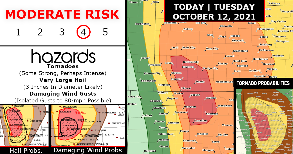
BREAKING WEATHER – Moderate Risk (Level 4 of 5) for Strong Tornadoes!
Confidence is increasing that multiple tornadic thunderstorms will move across portions of west-southwest Kansas into northeast Texas Panhandle and northwest Oklahoma this evening ( Oct 12, 2021) into the overnight.
Strong Tornadoes are expected, mainly after dark…
Scattered to numerous severe thunderstorms are expected to begin late this afternoon, peak this evening, and continue into tonight across parts of the central and southern Great Plains.
Several tornadoes, some of which may be strong, along with destructive hail and wind are possible.

Forecast thinking from the previous outlook is on track regarding the overall scenario, and confidence has increased for several long-track supercells capable of a couple strong and perhaps an intense tornado this evening/tonight.
As a result, this outlook update is introducing a 15-percent tornado probability and an associated Moderate Risk for portions of the northeast TX Panhandle and far northwest OK, and areas to the north-northwest into southwest KS.
TORNADO PROBABILITES

HAIL PROBABILITES

DAMAGING WIND GUSTS PROBABILITES

Storm-simulated model guidance continues to show quasi-discrete convective mode with storms that develop initially near the dryline and move east into richer low-level moisture and high SRH this evening.
Forecast soundings strongly favor discrete supercells and long-track, fast-moving supercells appear likely to traverse across the Moderate Risk.
Linear forcing and slightly drier/less unstable air will probably favor upscale growth into a band of storms in northwest KS and northeast CO, limiting the tornado risk.
SPC has adjusted the southeastern bound of the 10-percent tornado area to be farther northwest and mainly be confined to western and northwestern OK.
Closer Look – KANSAS

Kansas CWA – DDC

Closer Look – OKLAHOMA

Oklahoma CWA – OUN

Closer Look – TEXAS (Panhandle)

Texas CWA – AMA

ACTIVE TORNADO WATCHES

Tornado Watch for portions of Far Eastern Colorado, Western Kansas, Far Southwest Nebraska
Effective this Tuesday afternoon and evening from 345 PM until 1100 PM CDT.
Primary threats include…
Several tornadoes likely with a couple intense tornadoes possible!
Scattered large hail and isolated very large hail events to 3 inches in diameter likely!
Scattered damaging winds likely with isolated significant gusts to 80 mph possible!
SUMMARY…
Several supercells are expected to develop near the Colorado/Kansas border, before then moving east-northeast this evening.
All severe hazards are likely, some of which may be significant. Greatest tornado potential appears to be across southwest Kansas.

Are you prepared?
Now will be a good time to check your weather radios and have several ways to receive watches & warnings!
Download the WeatherBug app to receive free weather alerts! – Know Before | iOS App – Android App


