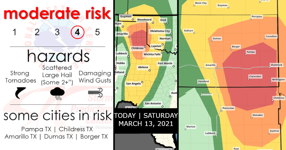
Moderate Risk is used for today’s Severe Weather and Tornado Threat!
Forecast for Today, Saturday, March 13, 2021!
UPDATE – PUBLIC SEVERE WEATHER OUTLOOK (PWO) Notice Below!

Forecast Blog (Continues)…
There will be a few hours the window for a couple of supercells to produce long-track, strong tornadoes and very large hail across the east-central/southeast TX Panhandle.

Tornado Probabilities!

Hail Probabilities!

Damaging Wind Probabilities!

Scattered to numerous severe storms are expected later today into early tonight from west Texas into western Oklahoma and southwestern Kansas.
The most significant severe weather threat, including strong tornadoes and very large hail, is expected this afternoon/evening across the east-central and southeast Texas Panhandle, where a Moderate Risk has been issued.


Detail Overview!
Southern High Plains through early tonight!
A deep closed low over AZ will progress eastward to the southern High Plains by the end of the period. In association with an embedded jet streak rotating northeastward around the eastern periphery of the low, a surface cyclone will develop north-northeastward from the TX Panhandle this afternoon to southwestern KS tonight. The cyclogenesis will draw the surface warm sector northward across western OK and the TX Panhandle today to the east of a developing dryline, which will focus severe storm development this afternoon/evening.
Some elevated convection is expected this morning from northeast NM northeastward into southwest KS, within the exit region of the mid-upper jet. Midlevel lapse rates/buoyancy will be sufficient for isolated large hail with this convection.
Farther southeast and following a lull in the overnight convection, the warm sector will spread northward today, beneath midlevel lapse rates greater than 8 C/km. Moderate buoyancy (MLCAPE of 1500-2000 J/kg) is expected south of the warm front and east of the dryline this afternoon, with only weak convective inhibition along the dryline.
Initial storm development is expected early-mid afternoon along the dryline in the vicinity of I-27 in TX Panhandle/South Plains.
These initial storms will move off the dryline and maintain a more discrete character as they encounter a moist, destabilizing warm sector with strong vertical shear.


Given boundary-layer dewpoints in the low 60s, afternoon temperatures of 65-70 F, effective bulk shear near 70 kt, and effective SRH in excess of 250 m2/s2, there will be a few hour window for a couple of supercells to produce long-track, strong tornadoes and very large hail across the east central/southeast TX Panhandle.
West of the initial supercells, squall line development is expected by evening as a Pacific cold front overtakes the dryline and the stronger height falls/ascent overspread the TX Panhandle and west central TX. Embedded supercell structures within the line will be capable of producing all hazards, though the overall severe threat will weaken with eastward extent during the early overnight hours, as a result of diminishing buoyancy. SPC/Storm Prediction Center: Thompson/Gleason.. 03/13/2021
Stay Tuned to Official NWS/News for the latest info and also be sure to Follow Live Storm Chasers for the latest LIVE updates!


