A regional tornado outbreak is looking unfortunately more likely for today afternoon & evening across Parts of the Lower to Mid Mississippi Valley!
The environment for tornadic supercells will be very ripe bringing with the threat possibility of significant strong and/or long-track tornadoes!
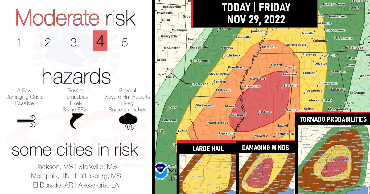
Overall severe thunderstorms capable of producing tornadoes, very large hail (some 2+ inches), and a few severe damaging wind gusts are expected this afternoon into the overnight period across parts of the lower to mid-Mississippi Valley and parts of the Southeast. A few strong intense tornadoes (Some EF2+) Long-track & Significant will be possible.
Several strong to intense thunderstorms are expected to organize and promote a relatively robust severe threat, particularly across the Southeast, where regionally higher instability should reside.
A level 4 out of 5 (Moderate Risk) has been issued!

As mentioned supercell structures are expected initially, with large hail, tornadoes, and a few severe gusts all likely. A few instances of 2+ inch diameter hail and/or strong tornadoes are possible with the more robust supercells.
Should a more dominant supercell develop, remain discrete, and traverse an axis of locally stronger surface heating/buoyancy, a long-tracked and intense tornado may occur.
TORNADO PROBABILITIES

The latest high-resolution guidance consensus suggests this scenario would be most likely across central MS, where a Category 4/Moderate risk is in place.
Later at night, storms should grow upscale into more linear segments as the surface cold front and greater low-level convergence approaches.
Damaging gusts should then become the main threat, though a few tornadoes remain possible.
DAMAGING WIND GUSTS PROBABILITIES

Supercell structures are expected initially, will have large hail, A few instances of 2+ inch diameter hail with the more robust supercells.
HAIL PROBABILITIES

We will update this post as needed throughout today!
In summary – Moderate Risk is Issued for today!!
HAZARDS include..
Several tornadoes, a few intense
Scattered large hail, some baseball size
Isolated damaging winds
Time/Location
Severe thunderstorms capable of producing tornadoes, very large hail, and a few severe wind gusts are expected this afternoon into the overnight period across parts of the lower to mid Mississippi Valley and parts of the Southeast. A few of those could be strong tornadoes!

Are you prepared?
Now will be a good time to check your weather radios and have several ways to receive watches & warnings!
Download the WeatherBug app to receive free weather alerts! – Know Before | iOS App – Android App
IMPORTANT:
Review your severe weather safety procedures for the possibility of dangerous weather today.
Stay tuned to NOAA Weather Radio, weather.gov, or other media for watches and warnings.


