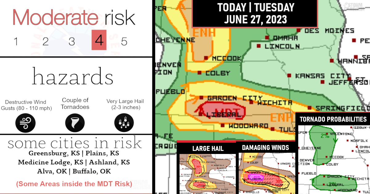
MODERATE Risk issued this afternoon for INTENSE damaging winds today!
Destructive wind gusts in excess of 80-110 mph part of intense supercells developing and evolving into a narrow bowing complex appears likely with the early threat of very large hail of 2-3 inches in diameter and a tornado across parts of southern Kansas and northern Oklahoma from late afternoon through tonight.

Initial thunderstorm development is expected by mid afternoon in the Raton Mesa vicinity, and storms will subsequently spread into southwest KS and the northern Panhandles by early evening.
The initial storms will likely consist of a few supercells capable of producing very large hail of 2-3 inches in diameter. A window of opportunity for a tornado or two with the more discrete supercells appears possible.
(Damaging Wind Probabilities)

However, thereafter, upscale growth into a small but particularly intense MCS appears probable, due to storm interactions/mergers.
Localized swaths of destructive severe wind gusts from 80-110 mph will be possible into tonight across southern KS/northern OK.
(Large Hail Probabilities)

A tornado or two should be the main threat initially with storm development as mentioned along with the large hail. So though the risk of the tornadoes is slim, there is still a chance before things turn into an intense wind machine!
(Tornado Probabilities)

Are you prepared?

Now will be a good time to check your weather radios and have several ways to receive watches & warnings!
Download the WeatherBug app to receive free weather alerts! – Know Before | iOS App – Android App
IMPORTANT:
Review your severe weather safety procedures for the possibility of dangerous weather today.
Stay tuned to NOAA Weather Radio, weather.gov, or other media for watches and warnings